
Evidence before inference.
RouteFrame separates community map records, primary procurement documents, reporting, vendor claims, estimates, and unknowns. Each category answers a different question and carries different limits.

What each source can support
Primary documents
Signed contracts, agenda packets, staff reports, policies, ordinances, audits, and grant records support only the claims stated in those documents.
Community map records
DeFlock and OpenStreetMap records identify community-mapped points and tags. They do not prove current activity, ownership, completeness, or exact installation precision.
Journalism
Approved newsroom reporting supplies public-interest context. Allegations, findings, official responses, and outcomes remain clearly separated.
Vendor claims
Product and performance descriptions are labeled as vendor-reported unless independently verified.
Route footprint calculation
- Ordinary routesOSRM returns normal driving alternatives. RouteFrame does not design evasion routes.
- Lower documented exposureAfter the standard route loads, pressing the documented-camera preference sends the same start, destination, and nearby loaded public camera points to OpenRouteService. The result is a lower-exposure preference based on incomplete records, not a certified camera-free route.
- National map dataCompressed national source snapshots load once, then a selected route corridor receives a current regional refresh.
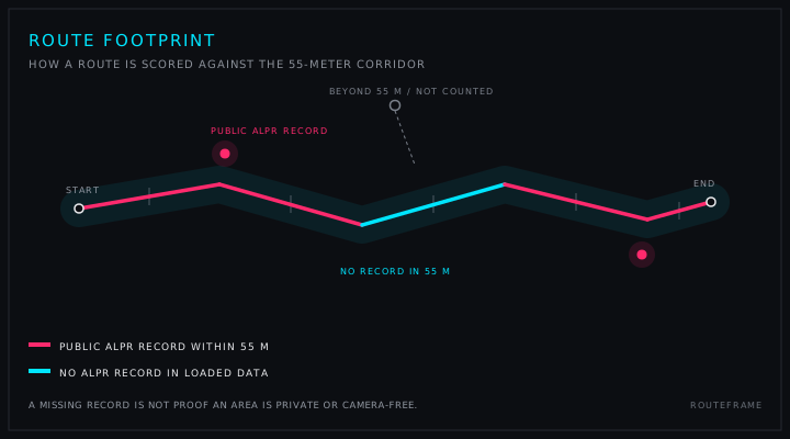
- Distance spansRoute geometry is divided into spans no longer than 50 meters.
- Proximity checkA span is marked near a loaded ALPR record when a point falls within 55 meters.
- Three statesNear a public record, no nearby record in loaded data, or not evaluated.
- Explicit limitNo-record spans are not labeled private, safe, camera-free, or unobserved.
Nationwide boundaries, snapshot-based records.
The county layer joins the current DeFlock ALPR regional cache to January 1, 2025 Census TIGERweb county-equivalent boundaries. It publishes mapped-record counts, records per 100 land square miles, and median nearest-record spacing. Zero means no joined record in the snapshot, not no cameras. The layer does not model field of view, road capture, current operation, or population exposure.
Direction is never inferred from an unreviewed tag.
Public orientation requires an eligible source, verification method, review date, confidence label, and an approximate designation. Eligible methods are an official public document, a reviewed public street image, a verified source image, or an authorized manual research review. Current community direction tags remain unverified source metadata and do not create a public orientation indicator.
Every modeled number keeps its assumptions visible.
Documented contract totals remain separate from modeled scenarios. Effective per-camera values divide a documented recurring total by a documented approved quantity and retain bundled-product warnings. Scenario outputs use user-visible camera quantity, unit price, installation, fees, replacement, price change, grant share, and contract duration. They are not invoices or confirmed expenditures.
New evidence changes the record, not the standard.
Material corrections require a record URL, the disputed field, and a public supporting source. RouteFrame can update, qualify, or remove a claim when stronger evidence appears. Conflicting evidence remains described until it can be resolved. Research review dates are not treated as event dates.